- Ingénieur d'état


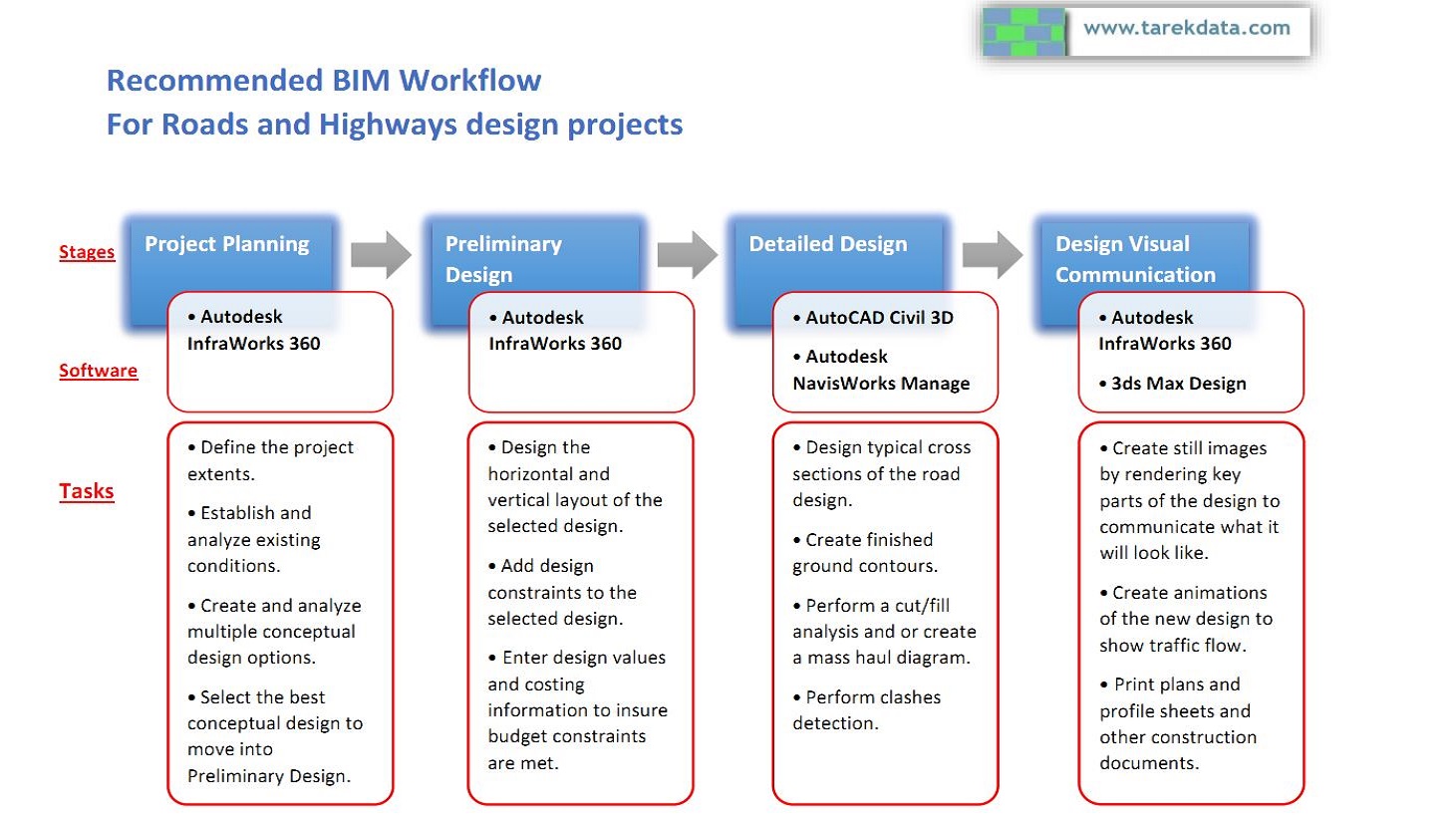
On this page you can find the recommended workflow for BIM (Building Information Modeling) application in Roads and Highways projects. The BIM workflow is summarized in four stages as follow:
BIM workflow stages :
Project Planning
Preliminary Design
Detailed Design
Design Visual Communication
1. Project Planning stage:
In this stage the BIM software Autodesk InfraWorks 360 will be used in objective to sketch layouts of the proposed design in order to evaluate multiple design alternatives and recommend solutions.
In the Project Planning stage the designer will focus on the following points as general design steps in roads and highways projects but not limited to.
Define the project extents.
Establish and analyze existing conditions.
Create and analyze multiple conceptual design options.
Select the best conceptual design to move into Preliminary Design.
2. Preliminary Design stage:
In this stage, the objective is to create engineered roads of the proposed design considering the best conceptual design selected in the previous stage.
With the help of Autodesk InfraWorks 360, the designer will perform the following tasks to create and select the preliminary design to move forward with.
Design the horizontal and vertical layout of the selected design.
Add design constraints to the selected design.
Enter design values and costing information to insure budget constraints are met.
3. Detailed Design stage:
In the Detailed Design stage, AutoCAD Civil 3D will be used in addition to Autodesk NavisWorks Manage. The objective is to create the more detailed design and drawings of the selected preliminary design by moving the design from the Autodesk InfraWorks 360 into the AutoCAD Civil 3D software where you then make any required adjustments to the alignments and profiles that came from the Autodesk InfraWorks 360 software. Also, in this stage, the clashes detection will be performed with the help of Autodesk Navisworks Manage.
In the Detailed Design stage the designer will focus on the following details tasks.
Design typical cross sections of the road design.
Create finished ground contours.
Perform a cut/fill analysis and or create a mass haul diagram.
Perform clashes detection.
4. Design Visual Communication stage:
In this stage, in addition to Autodesk InfraWorks 360, 3ds Max Design software will be used in objective to communicate the design visually for better imagining and understanding of the project from the stakeholders like those who are directly affected by the new road design whose are often want to know what the new transportation corridor is going to look like from a certain point of view.
In the Design Visual Communication stage, the designer will use the visualization tools to prepare the renders and output documents.
Create still images by rendering key parts of the design to communicate what it will look like.
Create animations of the new design to show traffic flow.
Print plans and profile sheets and other construction documents.
![]()
Storyboards for Roads simulation
Storyboards enable you to capture and compile views of the model to create a slideshow. The slides can follow a specific camera path to simulate driving down a new road or accessing neighboring businesses and/or residences. You can specify the transition between each shot and the camera speed. You can also add notes or captions to the slides to indicate specific points of interest in key frames. Multiple captions can be added to a single slide.
See hereunder an example of a Storyboard for Roads simulation exported to video.
DOHA 3D CITY MODEL - QATAR
Accurate 3D city model and its surrounding area. Suitable for Games, Architecture, Walkthrough, can be used for Town and Urban Planning, Education and Learning.